The map starts at the Palisades. Zoom out to explore LADWP's generating sources and supply connections. Select Outages for local outage reports, customers affected, crew status and estimated restoration times. Where does the Palisades get its power? ↓
LADWP outage reportsChecking…Checks every 5 minutes while open
From the region to your neighborhood
Where Does the Palisades Get Its Power?
From generating plants across LADWP’s shared system. Follow the dashed connections from selected plants to the Los Angeles grid. DS-66 in Brentwood, DS-29, DS-99 and the two pole-top stations receive and distribute that electricity. None of these local stations generates power.
Line labels use 2024 LADWP supply shares. “All solar” and “all gas” mean that entire energy category, not the individual plant. Connections are illustrations; they do not show cable routes or live flow.
—Outage locations in view
—Customers reported out in view
—Locations with crews working
Loading LADWP's latest available reports…
Outages & restoration
Explore your neighborhood
Generating sources · Annual supply shares
Explore the power network
Select a plant or a percentage. Dashed lines illustrate supply connections; percentages are LADWP-wide shares for 2024.
How the power reaches us
Make electricity
LADWP grid & receiving stationsCarry power into the local system
DS-29 · DS-99 · pole-tops · DS-66
NeighborhoodsLocal lines & transformers → homes and businesses
Solid lines are 34.5 kV routes recorded in LADWP’s public capacity map (retrieved October 3, 2026): red overhead, blue underground. DS-99 in the Highlands: the Royal–Monte Grande 1 Line from DS-122 on Mulholland Drive, identified by LADWP in 2025. DS-29: an underground path from Olympic Receiving Station, matching the 2013–2014 record. The capacity map does not say which 34.5 kV circuits are energized or which station each one feeds. For the neighborhood 4.8 kV lines, LADWP’s FiT+ circuits map does name the station and circuit: see Lines & Boxes.
These stations receive and distribute power. They do not generate it.
Distributing station Pole-top distribution Receiving station · Approximate locations
Solid lines: 34.5 kV routes recorded in LADWP’s public capacity map (October 3, 2026), red overhead and blue underground. DS-99’s overhead line is the Royal–Monte Grande 1 Line from DS-122 on Mulholland Drive, identified by LADWP in 2025. Olympic → DS-29 follows the recorded underground path. The map does not show which circuits are energized.
March 2026 project corridor · approximate street alignment
Marine replacement completed June 2019. The installed system connects the Gladstone vault to an array about two miles offshore.
palisadian.com
34.5 kV routes · LADWP capacity map Overhead Underground Vault Above/below groundDS-99: Royal–Monte Grande 1 Line · LADWP 2025DS-29: Olympic path · 2013–2014 recordEnergized circuits not published
Neighborhood lines · 4.8 kVOverhead on poles Underground Existing below-grade vault · from LADWP cable ends Modeled underground route in the street Modeled box · ~105 m spacingGray outlines at street zoom: lots and house numbers from the Rebuild MapSelect a line for its LADWP circuit (FiT+ map) · rebuild placements not published
Street lights · City inventory Bureau-maintained Not Bureau-maintained Modeled light on an unlit streetSelect a light for its pole design and lamp; hollow circles give a per-street estimateRecords do not confirm a light survived the fire or works
Loading map…
Installed ground-return systemUnderground land corridorMarine replacement · completed 2019Approximate published alignment
Reported outageAssigned / queuedCrews en routeCrews workingOther / not supplied34.5 kV overhead · capacity map34.5 kV underground · capacity mapStreet light · City inventory (optional)
About this map. Outage reports come from LADWP's official power outage map. Markers show approximate reported locations, not exact affected homes or service boundaries. Counts reflect the current map view and selected status. No marker does not confirm that power is on at an address. Restoration times are LADWP estimates and may change. “Checked” is when this page last retrieved the reports. For construction and permit progress, use the Rebuild Map →
Installed infrastructure · Updated September 28, 2026
Why a grounding line runs out to sea
Electricity needs a complete loop, so this ocean connection provides a backup way back if one of the main power lines fails. Saltwater carries current easily, and placing the connection offshore helps protect nearby pipes and equipment from stray current. LADWP explanation ?
The replacement was built. California’s State Lands Commission confirms that the new Sylmar ground-return electrode array was completed in June 2019. It connects to the Gladstone vault near Sunset and PCH and lies about two miles offshore. Its 36 concrete vaults contain 144 electrodes. State completion record ↗ · Project record ↗
The 2010–2014 stories describe earlier plans and local concerns about Topanga State Park and coastal traffic. The West Channel route in the 2014 map was superseded: LADWP’s 2016 revision retained the existing underground corridor and moved the marine replacement to Gladstone. The former offshore system was subsequently removed, according to its demolition contractor. Revised route ↗ · Old system removal ↗
The map shows the installed system. Lines follow approximate published alignments; they do not report live operating conditions.
Generating plants make the electricity. Brentwood’s DS-66, DS-29, DS-99 and the pole-top stations receive and distribute it. LADWP’s sources include Scattergood’s gas turbines near El Segundo, Hoover Dam, Palo Verde’s nuclear reactors in Arizona, and wind and solar projects across the region. Their electricity enters a shared grid that serves the Palisades and other Los Angeles neighborhoods.
One documented Westside connection runs from Scattergood Generating Station to Olympic Receiving Station on Centinela Avenue. Local distributing stations then reduce voltage for neighborhood circuits. Two local routes are documented below: the Royal–Monte Grande 1 Line that carries 34.5 kV power over the mountains from DS-122 to DS-99, and the underground path from Olympic to DS-29. LADWP: Scattergood–Olympic connection ↗
A connection from the Valley: LADWP’s November 2025 Tarzana–Olympic project describes an existing transmission corridor from Tarzana Receiving Station in the San Fernando Valley, through Kenter Canyon in Brentwood, to the Olympic system. The planned upgrade creates two 230-kV circuits. The document establishes the corridor and proposed work; it does not confirm completion or identify the incoming feeder for each Palisades distributing station. LADWP: Valley-to-Westside project ↗
These are annual shares of LADWP’s electricity supply. A plant shown on the map is an example within its energy category; the lines do not assign that entire category’s share to one plant.
Renewables
41%
Natural gas
30%
Nuclear
15%
Coal & petroleum
11%
Large hydro
3%
Within renewables: solar 15%, wind 14%, geothermal 9%, and eligible hydro 2% of the total supply. LADWP’s rounded subcategory figures do not add exactly to its 41% renewable total.
What has changed since 2024? The 11% coal share is historical. LADWP has since ended coal deliveries from Intermountain; its replacement units use natural gas and are hydrogen-capable. The 2024 figures do not describe today’s hourly mix.
A selection of LADWP-owned and contracted sources, not its entire supply or a live generation report. Select a plant to locate it on the map.
Natural gas · hydrogen-capable
Intermountain
Utah
This Utah site formerly supplied coal power. LADWP ended coal deliveries in late 2025. Its replacement units use natural gas and can accommodate hydrogen; this map does not establish a current hydrogen blend.
These stations reduce voltage and distribute electricity from the grid. They do not generate power. Select a location to see it on the same map.
What is documented: DS-99 and the Royal–Monte Grande 1 Line
In its 2025 Palisades Fire statements, LADWP identified one overhead 34.5 kV sub-transmission line in the area, the Royal–Monte Grande 1 Line, and said it de-energized the line’s Palisades end on January 7, 2025 by opening switches on the Encino side. “Monte Grande” is DS-99 on Monte Grande Place. “Royal” is at 15850 Mulholland Drive, above Sherman Oaks and Encino. A 2021 Coastal Commission permit covered replacing 38 wooden poles, some dating from 1935, on this line along Temescal Ridge Fire Road in Topanga State Park, and described the line as essential to serving the Palisades.
LADWP’s public capacity map records the route: a short underground section leaving DS-122, about 8 miles overhead west along the Mulholland ridge and south along Temescal Ridge, then about 1.3 miles underground into DS-99. That underground finish matches the September 25, 2026 observation that every wire at DS-99 is underground. The same map records a second, underground 34.5 kV cable from the Sunset/Marquez area up Palisades Drive to DS-99.
Why two feeds? Two connections into one station is normal design, not a contradiction. A tie like the Palisades Drive cable lets power flow either way: if the Royal line were out, DS-99 could be fed from Sunset; if the Sunset side were short, the Highlands cable could help in the other direction. LADWP’s 2025 plan to grow DS-99 from 8 to 30 MVA would make a second strong connection more important, not less. Which feed carries the load day to day is not published, so the Palisades Drive cable is drawn without an arrow.
is at 1840 S Centinela Avenue in West Los Angeles. CLUI’s 2013–2014 LADWP research identifies it as feeding DS-29. LADWP’s capacity map records a continuous underground 34.5 kV cable path of about 5.6 miles from Olympic, past DS-66 in Brentwood, along San Vicente and Sunset Boulevards to DS-29. The blue line follows that recorded path and is visible automatically. It is one path through a corridor of several parallel cables: the record shows five separate 34.5 kV cables between Olympic and Brentwood and three along Sunset west of Brentwood. DS-66 has its own cables from Olympic, and the DS-29 cables run past it in the same trench; the record does not name which cable serves which station.
What the capacity map does not say. It shows where 34.5 kV cable and conductor exist and whether each section is overhead or underground. It does not say which 34.5 kV circuits are energized, which station each one feeds, or how load is shared, and it cannot separate the DS-66–DS-29 sections built under the March 2026 plan from older cable. At the neighborhood level LADWP does publish more: its FiT+ Pilot Circuits Map labels every 4.8 kV line with its distributing station and circuit number, shown in the Lines & Boxes view. A public-records request for LADWP’s 34.5 kV feeder records is pending.
15345 W Sunset Boulevard · Sunset & Via de la Paz.
Recorded 34.5 kV route: underground from Olympic, past DS-66 in Brentwood, along San Vicente and Sunset, in a corridor shared with DS-66’s own cables. The cables meet at a vault on Sunset at Via de la Paz, about 200 feet from the station, where the westbound cable to the pole-tops begins. Underground supply reported September 23, 2026.
1433 N Monte Grande Place · Distributing station.
Incoming: the Royal–Monte Grande 1 Line, overhead across the ridge from DS-122 and underground for its last 1.3 miles, plus an underground cable up Palisades Drive. All incoming and outgoing wires at the station are underground, based on a visual inspection reported September 25, 2026.
In the Temescal Canyon Road right-of-way about 100 feet south of the southwest corner at Sunset: two 60-foot poles, a 46-foot pole and a platform with three transformers, plus an underground vault, conduit and cables (Coastal Commission record 5-16-1145-W, 2017). Built to relieve DS-29 circuit 29-05 (LADWP, 2016). The two pole-top stations go away once DS-29 is upgraded (DS-29 construction 2028–2031 in LADWP’s March 2026 schedule).
In underground, out above ground. The 34.5 kV feed from DS-29 arrives by cable along the south side of Sunset and down Temescal Canyon Road, about a quarter mile, and rises at the pole. The split from the Marquez cable happens at a vault on Sunset about 400 feet east of the intersection, marked on the map. From there 4.8 kV overhead lines leave north up Temescal Canyon Road, south toward the bluffs and east along Sunset, matching the overhead wires reported September 23, 2026. A separate cable on the north side of Sunset continues west to Marquez.
In the Sunset Boulevard right-of-way between Marquez Avenue and Marquez Place (16970 W Sunset), about 100 feet from the Marquez Place intersection: two 61-foot poles, a platform with three 833-kVA transformers, switches and an underground vault fed by about 1,000 feet of new conduit (Coastal Commission appeal record, 2017). Built to relieve DS-29 circuits 29-03 and 29-06 (LADWP, 2016). The two pole-top stations go away once DS-29 is upgraded (DS-29 construction 2028–2031 in LADWP’s March 2026 schedule).
In underground, out above ground. The 34.5 kV feed from DS-29 arrives by cable along Sunset and down Marquez Avenue, about 1.9 miles, to the vault beside the station and rises at the pole. From there 4.8 kV overhead lines leave along Sunset and into Marquez Knolls, matching the overhead wires reported September 23, 2026. The cable continues west along Sunset and up Palisades Drive to DS-99.
15850 Mulholland Drive · Distributing station above Sherman Oaks and Encino.
Valley-side start of the Royal–Monte Grande 1 Line to DS-99.
12200 W San Vicente Boulevard · Distributing station.
Recorded: its own underground 34.5 kV cables from Olympic, about 2.3 miles, in the same corridor as the DS-29 cables. Feeder placement at the site has not been observed.
Above ground to below ground. Red-ringed markers show where the Royal–Monte Grande 1 Line changes between overhead conductor and underground cable: above the Highlands, where it comes off its last pole and runs about 1.3 miles underground into DS-99, and at DS-122, where it leaves the station underground and climbs its first pole.
Vaults. Small blue-ringed circles mark where the recorded cables split or meet: on Sunset at Via de la Paz beside DS-29, on Sunset east of Temescal Canyon Road, on Sunset about 650 feet west of Temescal Canyon Road where the cable is recorded as two parallel runs between two vaults, on Sunset at the top of Marquez Avenue where the cable turns the corner without branching, beside the Marquez pole-top, and on the west side of Palisades Drive about 300 feet north of Sunset, where the record loops the Highlands cable off the road and back through a vault with no branch. Underground cable is spliced and switched in vaults, so each junction marks one; the 2017 Coastal Commission records confirm vaults at both pole-tops, and the capacity map shows the junctions, not the vault structures themselves.
Overhead and underground routes. Solid lines follow 34.5 kV routes in LADWP’s public capacity map, retrieved October 3, 2026: red where the map records overhead conductor, blue where it records underground cable. Arrows appear only where a source gives the direction of supply: LADWP’s statements for the Royal line and the 2013–2014 record for Olympic → DS-29. Reported feeder types at each site (September 23 and 25, 2026) are kept in the station details. The 2017 permits also describe underground vaults, conduits and cable connections at the pole-top installations. Underground cable at a station does not mean its entire incoming line is underground, and a recorded route is not confirmation that a circuit is energized.
LADWP’s March 2025 rebuilding document lists DS-29, DS-99, PTDS-195 and PTDS-198 as the Palisades’ distributing stations. It proposes transferring the two pole-top stations’ loads to an upgraded DS-29; that plan is not confirmation that the transfer or removal has happened.
Nearby is also marked. LADWP’s capacity map records several parallel underground 34.5 kV cables from Olympic into Brentwood: DS-66 has its own, and the DS-29 cables continue past it along San Vicente and Sunset. The record does not name which cable serves which station. LADWP’s March 26, 2026 plan identifies a new 34.5 kV connection between DS-66 and DS-29; use the separate planned-connection button to follow its approximate corridor along Sunset, Allenford / 26th Street and San Vicente. The March 2026 source distinguishes designed and constructed sections; it does not confirm an energized connection. The underground work along Sunset toward Chautauqua is this project: 12.5 miles of new underground in the Sunset corridor, made up of the 6.0-mile 34.5 kV trunk from DS-66 to DS-29, a 3.9-mile 12 kV mainline east from DS-29 to Allenford Avenue and a 2.6-mile 12 kV mainline west from DS-29 to Palisades Drive. The plan has Sunset Boulevard construction running now through June 2027, DS-29 rebuilt 2028 through 2031, and up to 45 miles of neighborhood undergrounding 2027 through 2030; the two pole-top stations go away once DS-29 is upgraded. Dates are LADWP planning targets. The “All 34.5 kV lines nearby” button adds every 34.5 kV line the capacity map records in the area, for context.
Station pins are approximate address or intersection locations. DS-29 and DS-99 use the City of Los Angeles locator; both pole-top pins sit at the 34.5 kV risers recorded in LADWP’s capacity map, corrected October 3, 2026 against the 2017 Coastal Commission records (the Marquez pin had been about 450 m too far west); Olympic uses Esri address geocoding of LADWP’s published address, checked September 24, 2026; DS-122 uses its OpenStreetMap station outline, checked October 3, 2026. The Highlands and the two Sunset pole-top locations were added September 23, 2026. Pins show locations, not live operating status or exact service boundaries.
Street lighting · Added October 3, 2026
Street lights: who owns them and how a street gets them
Street lights are not part of LADWP’s system. The City’s Bureau of Street Lighting builds and maintains them, and the property owners on each lit street pay for them through an assessment on the County tax bill. A street has lights only if its owners once formed a lighting district; a street without lights, such as parts of Radcliffe Avenue, never did. LADWP’s undergrounding and rebuilding plans do not add street lights.
On the map. The button adds every light in the Bureau’s inventory for the Palisades area, 2,392 records retrieved October 3, 2026. Select a light to see a picture of its post design, a City photo for the decorative designs and the Bureau’s standard-plan drawing for City Design poles, plus its lamp type and wattage, its status and a link to the City’s record for that pole. The City publishes a photo for each standard pole family as well, so nearly every light now shows a picture. The handsome lights on Sunset around Palisades Village are in the inventory as 23 “15.5-foot ELA dual-arm custom poles,” Caruso’s own design, maintained privately rather than by the Bureau, so they appear as gray dots; select one for the City’s photo. The City’s historic-designs map covers only decorative and historic designs, grouped by family, not the standard concrete and metal poles that light most streets. Gray dots are lights the Bureau does not maintain. The inventory does not confirm that a pole survived the January 2025 fire or that a light is working; the Bureau’s post-fire work so far is repair of existing lights, prioritizing schools, occupied homes and major roads.
Getting lights on a street that has none. The Bureau’s petition for a modern street lighting system covers residential streets “where street lighting does not exist.” Owners representing at least 70 percent of the street’s frontage sign; questionnaires confirm support; then every affected owner receives a Proposition 218 ballot on the assessment. The form’s estimates: about $5,000 per 50 feet of frontage one time, plus about $95 per property per year for maintenance and power. Ornamental systems run roughly $7,500 to $10,000 per 50 feet and about $130 per year. Contact: bsl.streetlighting@lacity.org, Community Impact Division, 1149 S. Broadway, Suite 200.
If your street only had a light on a DWP pole. A luminaire hung on a wood utility pole is either a Bureau fixture on a shared pole or an LADWP-owned one. Check the Street Lights view on your block: an amber dot where the pole light stood means it is a Bureau light and its post-fire repair program covers restoring it; no dot means it was never a Bureau light and no one is obliged to replace it. When LADWP removes the poles for undergrounding, any light on them goes too, and neither LADWP’s March 2026 plan nor the Bureau’s recovery work provides replacements, so an overhead-only block ends up with no lights unless its owners act. The options: petition for a modern system at about $5,000 per 50 feet of frontage, roughly $5,000 to $6,000 for a typical Alphabet lot, plus about $95 a year; petition for an ornamental system at about $7,500 to $10,000 per 50 feet plus about $130 a year; petition by block rather than by whole street, since the form is written “between X and Y”; ask the Council office and the Bureau whether lights lost with the poles qualify for fire-recovery funding, the one route that might cost owners nothing and the one no one has answered; or rely on private lighting on each lot, with no City maintenance and no assessment. The 1913 Act lets the one-time assessment be spread over years on the County tax bill; confirm the current terms with the Bureau. The Bureau’s spring 2026 citywide Prop 218 ballot to raise the existing lighting assessment failed: of 166,789 ballots returned by June 2, 2026, the weighted tally was 79 percent opposed, and the Council abandoned the proposed $111.8 million district on June 26, 2026 (Council File 26-0331). The existing assessment and the estimates above stand, and the Bureau’s stated repair time for service requests remains about a year.
Modeled lights for streets that have none. Using the City’s official street centerlines, every public street in 90272 with no light in the inventory along it gets hollow amber circles about 150 feet apart, staggered at the property lines, the City and County spacing for a local residential street. Select one for the street’s count, its length and a rough one-time assessment at the Bureau’s $5,000 per 50 feet of frontage, both sides. The modeled pole is the Bureau’s standard plan CD 851, a 26-foot concrete pole, with the 31-foot metal CD 959 as the alternative, both with LED luminaires. These are estimates to size a petition, not a Bureau design; private and unidentified streets are left out.
What a new lighting district costs an owner
System
One-time, per 50 ft of frontage
Typical 50–60 ft lot
Each year
Modern (City standard pole, LED)
about $5,000
about $5,000–6,000
about $95
Ornamental (decorative post)
about $7,500–10,000
about $7,500–12,000
about $130
Citywide Prop 218 ballot, spring 2026 (District No. 5500)
Proposed
$111.8 million assessment increase for repairs and maintenance
Ballots returned by June 2, 2026
166,789
Weighted vote
79.29% opposed · 18.74% in favor
Outcome
Failed; Council abandoned the district June 26, 2026 (Council File 26-0331)
Effect
Existing assessment unchanged; Bureau repair time stays about a year; new districts by petition still need their own Prop 218 ballot
Prices are the Bureau of Street Lighting’s petition-form estimates (revised January 2024), assessed on the County tax bill and spreadable over years under the 1913 Act; the Bureau sets the final figure for each district after design.
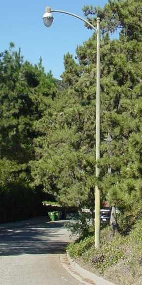
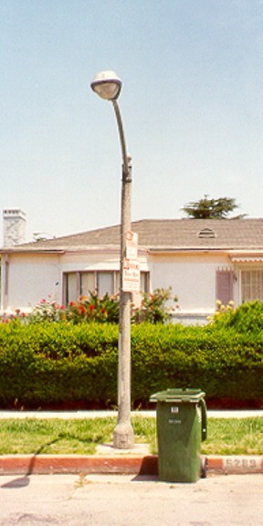
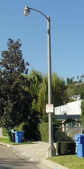
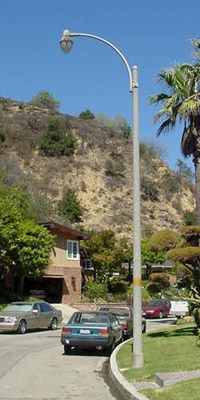
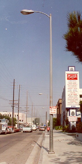
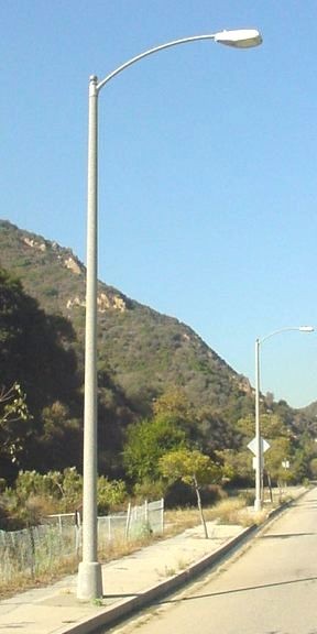
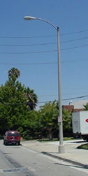
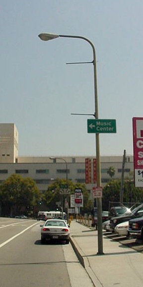
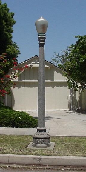
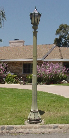
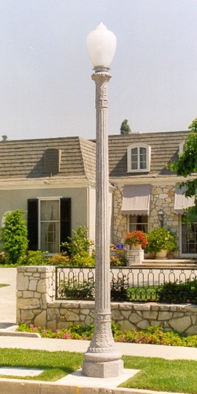
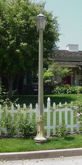
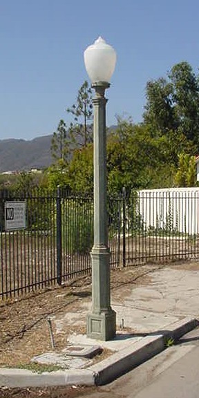
What the designs look like. City photos of the pole designs that stand in the Palisades today, with how many of each the Bureau’s inventory lists here. A petition for a new system chooses between the two modern standards (CD 851 or CD 959) at the modern price, or an ornamental post at the higher price; the Bureau matches an existing ornamental street where it can.
Modern, standard arm poles (about $5,000 per 50 ft)
CD 951 · 391 in the Palisades Concrete pole, curved arm. The most common light in the Palisades.CD 852 · 330 in the Palisades Concrete pole, curved arm.CD 814 · 223 in the Palisades Concrete pole, long tapered arm.CD 851 · 191 in the Palisades 26-foot concrete pole. The usual choice for a new residential system.CD 953 · 152 in the Palisades Concrete pole, boulevard arm, on the larger streets.CD 856 · 164 in the Palisades Metal pole, curved arm.CD 855 · 62 in the Palisades Metal pole, curved arm.CD 959 · none in the Palisades yet 31-foot metal pole with LED luminaire. The other standard offered for new systems.
Ornamental, post-top lanterns (about $7,500–10,000 per 50 ft)
Lalux 11 · 206 in the Palisades Fluted concrete post with an acorn lantern, the classic 1920s–30s Palisades post.La Primavera · 103 in the Palisades Cast-iron post with a lantern top, common in the Alphabet streets.CD 803 · 80 in the Palisades Ornamental concrete post with a round globe.King Ferronite 61 · 73 in the Palisades Slender cast-iron post with a lantern top.Revello 1-Lite · 48 in the Palisades Cast-iron post with a single globe, as on Revello Drive.
Photos: Bureau of Street Lighting post-design images. Counts are poles of that family in the City inventory within this map’s Palisades extent; click any light in the Street Lights view for its own design, lamp and record.
Design standard. The City treats a local street as 40 feet wide, lit to 0.4 footcandles with a 4-to-1 uniformity ratio, using a 26-foot concrete pole or a 31-foot metal pole in residential areas, placed at property lines where possible and matching the neighboring system when one with more than ten poles exists. The City standard does not print a single spacing figure; the County guideline for the same lighting level, often used as the rule of thumb, is staggered poles 130 to 170 feet apart. The Village streetscape on Sunset between Swarthmore and Monument, with new street lights, sidewalks and trees, is privately funded by Caruso under a 2016 commitment and approved by the Board of Public Works; it is a one-off, not a program for residential streets.
As homes return with electric heating, appliances and EV charging, reliable service depends on enough capacity throughout the network: stations, neighborhood lines and local transformers. These published plans describe how LADWP proposes to increase capacity and move lines underground.
Sources reviewed September 23, 2026. Proposed work and planning dates below are not confirmation that equipment is operating or that construction is complete.
More power-delivery capacity
LADWP's March 2026 presentation says the completed local system would have nearly twice the capacity it had then. Work includes upgrading DS-29, new 12-kV neighborhood circuits, a 34.5-kV underground connection between DS-66 and DS-29, and undergrounding up to 45 miles of overhead lines where feasible.
The Huntington Palisades, underground for decades, has no above-ground electrical cabinets: a street survey on October 9, 2026 found its transformers and splices below grade, in vaults under square grated steel lids set flush in the pavement (pictured in the map popups). LADWP’s rebuild plan takes a different approach, pad-mounted transformers, the green cabinets at the curb or in a front yard. LADWP has not published transformer locations for the rebuild; it plans Board authority for Right-of-Entry in the second quarter of 2026 and property-owner outreach on equipment placement and easements from the third quarter of 2026. For what a rebuilt block looks like and how to prepare your house, see the underground utilities cutaway.
On the map, the view shows which streets are already underground (dotted blue, served by pad-mounted transformers) and which are still overhead on poles (dotted red), from LADWP’s capacity map. In the Palisades, LADWP counts 27 miles of existing underground and 45 miles of overhead line. Zoomed in, solid green dots mark the existing vault sites in the neighborhoods that are already underground, the Huntington Palisades for example. Those vaults are in place today: underground cable is run from one vault to the next, so each place where LADWP’s recorded cable runs end is where a below-grade transformer or splice vault sits. The record gives the cable ends rather than an equipment list, and it carries no attribute for the equipment at all, which is why the map at first assumed above-ground cabinets; the lid may sit a few feet from its dot, and the record does not say whether a vault holds a transformer or only splices. Where two or three cable ends sit within about 40 feet they are shown as one site. The blue lines are the primary cable only. Streets without a line of their own, such as Ocampo and Chapala Drives, are served from the vaults on the neighboring streets by shorter secondary cable that the record does not draw.
Which station serves your street. LADWP’s FiT+ Pilot Circuits Map, published for its Feed-in Tariff program on the same public ArcGIS account as the capacity map, labels every 4.8 kV line with its feeder ID: the distributing station number and circuit, for example 029-11 for DS-29 circuit 11 along Pampas Ricas Boulevard, or 066-17 for the DS-66 circuit that serves the Chautauqua side of the Huntington from Brentwood. Select any neighborhood line or green dot for its circuit. The map’s line geometry matches the capacity map to within a few feet, and its circuit numbers agree with LADWP’s 2016 notice that the Marquez pole-top station relieves circuits 29-03 and 29-06 and the Temescal station relieves 29-05. The FiT+ dataset covers the DS-29 and DS-66 circuits; it does not include the Highlands (DS-99), and it says nothing about which circuits are energized.
A systematic estimate for the rest of town. The already-underground areas give a yardstick: LADWP’s record shows a vault site about every 105 m (345 feet) of underground cable there, roughly one for every five to seven lots. Those sites include splice vaults as well as transformer vaults, so transformers alone are fewer, consistent with the 8 to 10 homes per transformer discussed in early planning. Hollow green circles apply that spacing along the streets whose homes are served overhead today, placed at the street frontage rather than on the old backyard lines, because LADWP’s scenario moves service underground in the street with the box at the front of the lot. A dotted green line marks the modeled underground route down each of those streets, and the circles on it show about how many boxes the street would need. They sit on the centerline because the side is not known: the boxes go on whichever side LADWP runs the primary cable, in a parkway or front yard, and serve lots on both sides. They are modeled, not planned: LADWP will set actual locations with property owners through Right-of-Entry outreach starting in the third quarter of 2026. Zoomed to street level, the map also draws the lot lines and house numbers from the Rebuild Map, so you can see which frontage a circle falls on.
The Huntington comparison. The Huntington shows what a Palisades neighborhood looks like with its equipment below grade: a vault about every 345 feet of cable and nothing above ground. Counting county parcels against LADWP’s cable record, the Huntington tract has about 470 homes on 79 vault sites, 5.9 homes per site, or 9.6 per site where two cable runs meet, which is where a transformer is most likely. The hollow circles on the overhead streets already run lighter than that: on the Alphabet streets they work out to about 9.7 homes per circle, and across the Palisades about 7.3, in line with the 8 to 10 homes per transformer LADWP spoke of in early planning. So the circles are not padded; a street would need bigger transformers and longer secondary runs to get by with fewer, and the rebuilt homes pull the other way, all-electric with heat pumps, EV chargers and 200- to 400-amp panels, so each transformer serves fewer of them than a 1950s unit did. Where a pad-mounted design does save is splices: a cabinet takes its splices inside, where the Huntington uses separate splice vaults. The stronger point the Huntington makes is not about count at all: LADWP has run this neighborhood for decades on below-grade vaults in these soils and streets, and its rebuild design offers only above-ground cabinets. Whether a vault option exists, and at what cost, is a fair question for the Right-of-Entry outreach.
The March 2025 proposal calls for expanding DS-29 and DS-99, transferring the loads of PTDS-195 and PTDS-198 to upgraded DS-29, then removing those two pole-top stations. Their removal and firm removal dates have not been verified.
LADWP's design places wires underground but retains transformers and switches on above-ground pads, on private property or in the public right-of-way. Easements may be needed. Some shortened poles can remain for telecommunications until those lines also move underground. Equipment locations, dimensions and screening need site-specific confirmation.
A change from 100 to 400 amps gives four times the rated current capacity. Electricity use depends on the equipment running at the same time. LADWP's July 2026 rebuilding instructions cover single-phase service up to 400 amps; they do not require every home to install 400 amps. Larger services require LADWP engineering design.
LADWP's March 2025 proposal lists approximately 40 MVA of pre-fire peak demand and 45 MVA after reconstruction, about a 13% increase using its rounded totals. This is an early forecast, not a measurement of demand today or proof of spare capacity. MVA measures electrical load or equipment capacity; it is not annual electricity consumption. Read the original demand table ↗
Published station capacity figures
The March 2025 proposal lists DS-29 increasing from 35 to 75 MVA and DS-99 from 8 to 30 MVA. LADWP's rebuilding webpage separately lists a 90-MW goal for DS-29. MVA and MW are different measures; these figures should not be treated as interchangeable or as today's usable capacity. Final ratings and in-service dates need LADWP confirmation.
Dates can change with permitting, access, materials and field conditions. DS-29's start year differs between the March presentation (2028) and April newsletter (2027); confirm the current schedule with LADWP. April 2026 newsletter ↗ · March 2026 schedule ↗
What still needs confirmation
An updated peak-demand forecast accounting for returning households, EV charging and electric heating.
Usable station, feeder and transformer capacity each year, including during construction and equipment outages.
Dates for transferring the pole-top stations' loads and removing the equipment.
Locations and appearance of above-ground equipment, including screening and feasible underground alternatives.
The sources linked here do not establish that every returning household's future demand is covered, or that brownouts are expected. LADWP rebuilding information & contacts ↗
Reading the network map. Solid routes are selected LADWP-labeled records from the California Energy Commission’s transmission dataset (CC BY 4.0), retrieved September 23, 2026; the service was updated July 2025 and individual records can be older. These approximate routes cover California and do not show every line, local circuit or service boundary. Blue means recorded underground; red means recorded overhead. These route records do not identify current power-flow direction or the generating plants supplying each line. A record edit date is not a live power reading. Colored dashed connections illustrate selected generating sources contributing to LADWP’s shared grid; their curves are diagrams, not physical routes. Percentage labels use the 2024 LADWP Power Content Label and LADWP’s Intermountain history. Repeated solar labels refer to the same solar total. Unmapped projects also contribute; these selected examples do not cover every source. Plant locations use EIA plant-location records distributed by Esri (February 2025); fuel and supply descriptions use the linked LADWP sources, including its later Intermountain update. Markers represent approximate plant sites. No line or plant symbol reports current operating status.